The Mysterious Young Mariners’ Pool at Newcastle Baths
The Young Mariners’ Pool at Newcastle Baths has become a local legend, with debates continuing over its existence and fate.
Some swear they once “jumped off Africa,” some believe a beautiful tile mosaic map of the world still lies underneath the sand, and others don’t think the map ever existed. So, what happened to Newcastle’s Young Mariners Pool?
In 1934, Newcastle council proposed to build a one-metre-high wall at the southern end of Newcastle Ocean Baths to protect it from rough seas and sand. This area would serve as a paddling pool for children. By 1936, workers had hollowed out a shallow oval in the rocks, 45 cm deep, with waste material used to fill a low triangular section between the new pool, the southern wall of the Ocean Baths, and the beach promenade. Larger rocks reinforced other concrete walls along the beach, while smaller rocks were used in the rockeries along Watt Street. Later, the paddling pool’s bottom was covered with sand to prevent injuries.
The Birth of the Mariners’ Pool
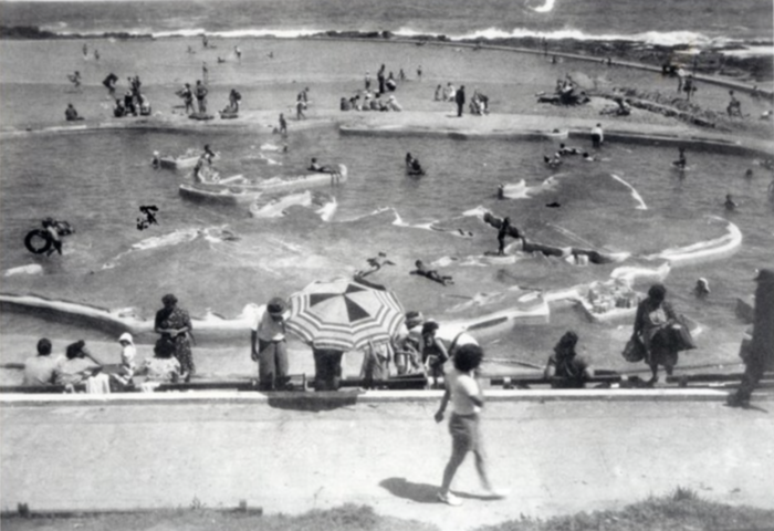
In January 1937, Newcastle City Council announced that a new attraction on Newcastle Beach would be built: a paddling pool and model yacht pool on the rock area near the Ocean Baths. It would be a “world in miniature”, where young mariners could take “a two-minute cruise from Australia to the South Pole, or a world voyage in a quarter of an hour.”
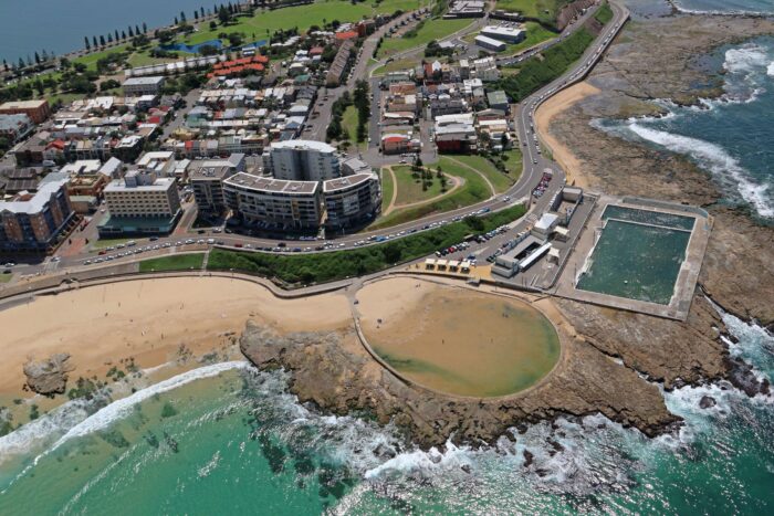
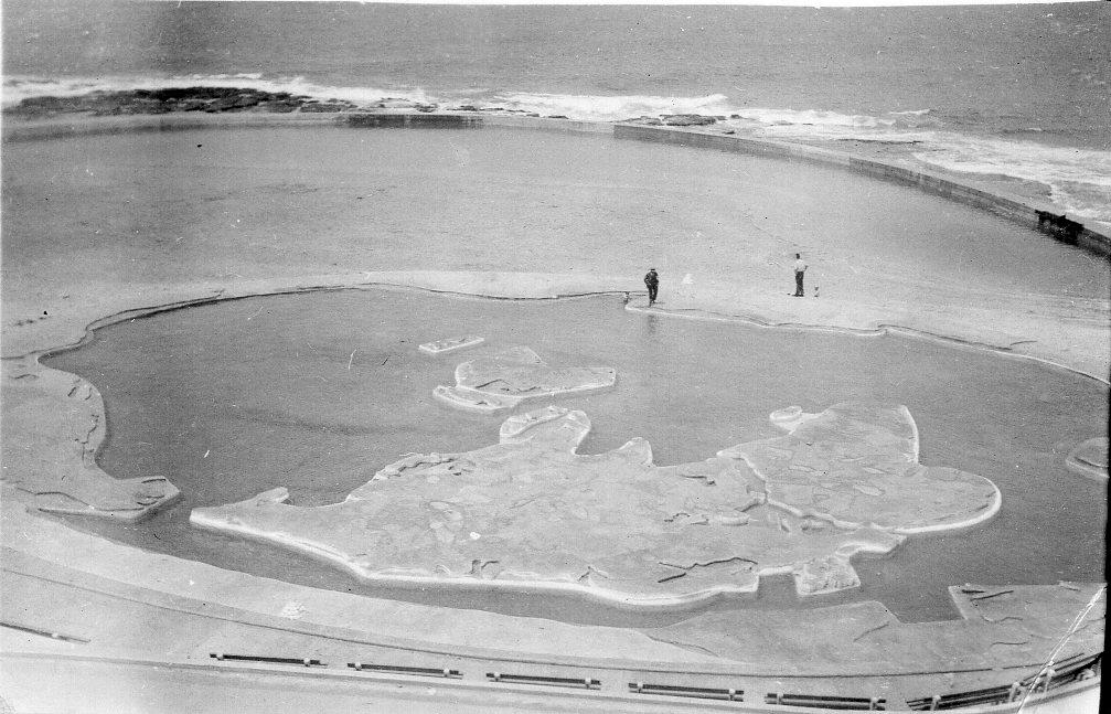
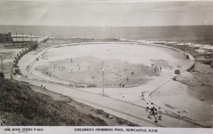
The Mariners’ Pool, later known as the Geographical or Map Pool, was constructed. This circular pool, 20 meters in diameter, featured a pigmented cement map of the world on its bottom. The Commonwealth countries were dyed red, and the rest green, with the raised landmasses 60 cm thick and 20 cm above the waterline.
The pool’s appeal extended beyond its intended audience of tiny children, and it often became overcrowded. City Engineer Mr LJ Price proposed building a larger pool to alleviate this.
The Canoe Pool Emerges
In 1939, the Canoe Pool was constructed beside the Map Pool. This concrete pool, with a maximum depth of 1.2 meters controlled by sluice gates, was designed for sailing small canoes. Filled by waves at every high tide, the geographical pool would also fill from the Canoe Pool, ensuring a continuous water flow.
The first high tide filled the Canoe Pool on 8 November 1939, after the sluice gates were closed. Later that year, pumping equipment was installed, allowing fresh salt water to be pumped into the pools when needed. On busy days, the pumps ran continuously to meet demand.
The late Peter Walmsley, manager of the Newcastle Ocean Baths from 1970 – 2000 and a childhood friend of famed engineer Ben Lexcen, recalled sailing toy boats across the Map Pool in the 1940s. He believed the pool began to fall into disrepair in the late 1960s.
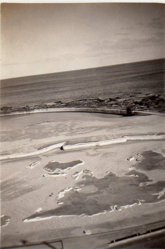
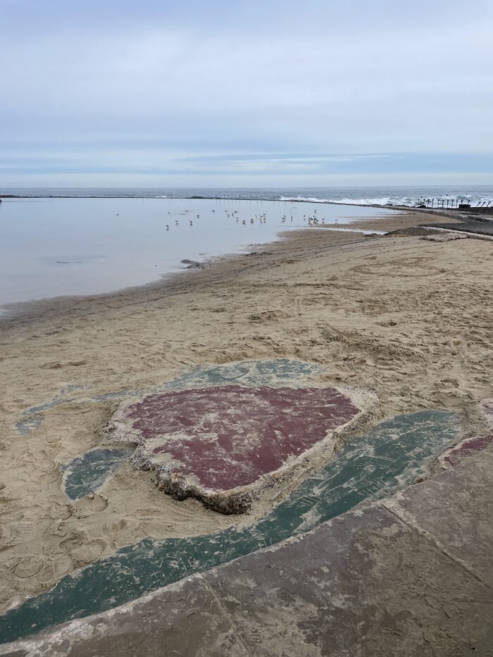
In 1981, Mr Keith Swan, the Deputy Town Clerk of Newcastle City Council, mentioned that the council removed sand from the map whenever it got covered. However, state legislation later prohibited the removal of sand from beaches. The main challenge was keeping the sand off the map, as it returned with every high tide. By the early 1970s, nature had successfully covered the world with sand.
The Map Pool water became murky due to trapped water, leading to the installation of pumps to bring in fresh water from the Ocean Baths. However, the high cost of pumping and maintenance led to the world map items being removed from the pool after a study in the 1980s.
Today, mainly referred to as ‘the map pool,’ the mystery of the Young Mariners Pool remains a topic of local intrigue and nostalgia. The pool remains a popular swimming spot for families with young children, and if you look closely, you’ll still see the faded, coloured remnants of the map around the very edge of the pool with a few more colourful remnants being uncovered by big swells in July 2024.
Story by Carol Duncan, Lost Newcastle.